Sensor System Creates Digital Maps In Disaster Zones (+VIDEO)
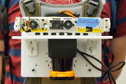
A prototype sensor system that would let first responders in disaster zones create digital maps was lately invented by MIT researchers. Due to this technology those, who are not present at the site, could get an exact description of the area. With the help of an integrated laser rangefinder, accelerometers, gyroscopes, and a camera the wearable system automatically creates a map of the environment. The camera takes a snapshot of its surroundings every few meters and software extracts hundreds of visual features from the image. The wearer could also use a handheld pushbutton device, which can be connected to the sensor system, to identify particular locations at the map. It is planned that emergency responders could use a similar system to add voice or text tags to the map to indicate structural damages, toxic spills, etc.
Via:psfk.com
| Tweet |


